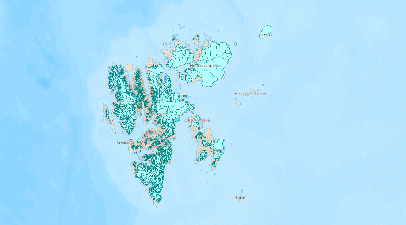
Glacier
area outlines at Svalbard for 1936, 1966-1971, 2001-2010 and 2020
NPI has generated a complete digitized glacier inventory for the Svalbard archipelago for the years 2001-2010 and 2020. The 2001-2010 inventory was achieved using various satellites (ASTER, SPOT and Landsat), and the 2020 inventory was created using Sentinel-2 imagery as a part of the project Copernicus Glacier Service (described in the NVE report by Andreassen et al. 2021). A historical inventory of Glacier Area Outlines (GAO) based on aerial photography is also available for the years 1936 and 1966-1971. This does not, however, cover the whole archipelago. The data are available as a layer in Svalbardkartet and the datasets can be found in The Norwegian Polar Data Centre.